


$
- Price is in US dollars and excludes tax This is a secure SSL encrypted payment.

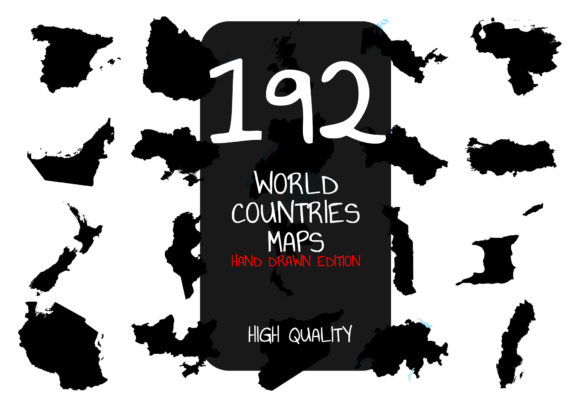
192 Hand Drawn World Countries Political Maps
Pack of hand-drawn maps for 192 world countries. All maps are made of 100% hand-drawn shapes, which makes them really useful for different graphical or printing projects. The folder & files is very well organized, with file named appropriately. You are free to use them for POD sites or your own e-commerce shop.
This package is covering almost every political country map of the world. These are provided as a PNG or JPEG file format, as well as in the filled shapes or just outline version.
Featured:
– 192 political country maps
– JPEG and PNG files
– Filled shapes and outlined maps
List of countries:
– Afghanistan
– Albania
– Algeria
– Andora
– Angola
– Antigua and Barbuda
– Argentina
– Armenia
– Australia
– Austria
– Azerbaijan
– The Bahamas
– Bangladesh
– Barbados
– Belarus
– Belgium
– Belize
– Benin
– Bolivia
– Bosnia and Herzegovina
– Botswana
– Brazil
– Brunei
– Bulgaria
– Burkina Faso (Upper Volta)
– Myanmar (Burma)
– Burundi
– Cabo Verde
– Cambodia
– Cameroon
– Canada
– The Cayman Islands
– Central African Republic
– Chad
– Chile
– China
– Colombia
– Comoros
– Costa Rica
– Cote d’Ivoire (Ivory Coast)
– Croatia
– Cuba
– Cyprus
– Czech Republic
– Democratic Republic of the Congo
– Denmark
– Djibouti
– Dominica
– Dominican Republic
– Ecuador
– Egypt
– El Salvador
– Equatorial Guinea
– Eritrea
– Estonia
– Eswatini
– Ethiopia
– Fiji
– Finland
– France
– Gabon
– The Gambia
– Georgia
– Germany
– Ghana
– Greece
– Grenada
– Guatemala
– Guinea
– Guinea-Bissau
– Guyana
– Haiti
– Honduras
– Hungary
– Iceland
– India
– Indonesia
– Iran
– Iraq
– Ireland
– Israel
– Italy
– Jamaica
– Japan
– Jordan
– Kazakhstan
– Kenya
– Republic of Kiribati
– Kosovo
– Kuwait
– Kyrgyzstan
– Laos
– Latvia
– Lebanon
– Lesotho
– Liberia
– Libya
– Liechtenstein
– Lithuania
– Luxembourg
– Madagascar
– Malawi
– Malaysia
– Maldives
– Mali
– Malta
– Marshall Islands
– Mauritania
– Mauritius
– Mexico
– Micronesia
– Moldova
– Monaco
– Mongolia
– Montenegro
– Morocco
– Mozambique
– Namibia
– Nauru
– Nepal
– The Netherlands
– Nicaragua
– Niger
– Nigeria
– North Macedonia
– Norway
– Oman
– Pakistan
– Panama
– Papua New Guinea
– Paraguay
– Peru
– Philippines
– Poland
– Portugal
– Qatar
– South Korea
– Republic of the Congo
– Romania
– Russia
– Rwanda
– Saint Kitts and Nevis
– Samoa
– San Marino
– Sao Tome and Principe
– Saudi Arabia
– Senegal
– Serbia
– Seychelles
– Sierra Leone
– Singapore
– Slovakia
– Slovenia
– The Solomon Islands
– Somalia
– South Africa
– South Sudan
– Spain
– Sri Lanka
– Sudan
– Suriname
– Sweden
– Switzerland
– Syria
– Tajikistan
– Tanzania
– Thailand
– Togo
– Trinidad and Tobago
– Tunisia
– Tonga
– New Zealand
– Turkey
– Turkmenistan
– Tuvalu
– Uganda
– Ukraine
– United Arab Emirates
– United Kingdom
– Uruguay
– Uzbekistan
– Venezuela
– Vietnam
– Yemen
– Zambia
– Zimbabwe
– United States of America
– USA + Hawai + Alaska
– Palau
– Saint Lucia
– Vanuatu
– Saint Vincent and the Grenadines
– Bahrain
What’s Included?
192 PNG + JPEG files (Outlined map design).
192 PNG + JPEG files (Filled map design).
Great for your t-shirts, poster, KDP books, coloring books, low-content books, merchandise, tote bag, art prints or any graphical and gaming projects that you need.
IMPORTANT NOTE:
All designs are outlined and not editable, PNG + JPEG format only with transparent background.
Some images include significant bodies of water in blue
Highlighting Features:
192 hand drawn world countries maps
JPEG and PNG file formats, all in high resolution 300 DPI, and with two types of designs, outlined and filled.
PNG files are with a transparent background on 300 dpi
Files work with all image editing softwares till today